T-MARS project
Terrestrial Mineral Analysis by Remote Sensing
T-MARS project was born to meet one of the main goals in the field of planetary exploration : to document the geological record and processes that have shaped the surface of the terrestrial planets, their moons, icy satellites and asteroids [1].
At regional scale
Remote sensing data acquired by satellites, also known as satellite imagery, are the first components that can provide information on geological processes. Thus, space-based remote sensing instruments will :
- Acquire data in different regions of the electromagnetic spectrum. This means that the instrument on the satellite measures the strength of the sun's rays that are reflected from the surface of the Earth or other planets. This measurement is performed for different wavelengths, depending on the configuration of the instrument.
- Provide information about the properties of the surface at the meter to kilometer scale. The strength of the signal received and recorded by the instrument depends on the properties of the surface targeted by the satellite. Thus, the analysis of the signal strength in several wavelengths (the so-called spectral signature of the surface) allows the identification of the surface. In our case, the surfaces of interest are those where geological processes are apparent.
Remote sensing data is a crucial tool to establish the global to regional context of geologic processes and is essential to assess the locations that need to be studied at the local scale.
At global scale
On the surface of the Earth or another celestial body, landers, rovers or humans can study geological processes at the local scale of a few meters or less.
Landers and rovers that have been on Mars, on the Moon or on comets have mostly relied on the use of remote sensing instruments near the surface to characterize the surface at such a fine scale.
The analysis of the samples, on site or once they are brought back to Earth, provides the most detailed information. This allows thorough isotopic, elemental and mineralogical analyses to be carried out.
The project in five aspects

Aspect 1
Develop new scientific knowledge regarding a specific geological process that has shaped the surface of Mars (hydrothermal systems)

Aspect 2
Characterize biosignatures and develop detection methods applicable to space missions

Aspect 3
Acquire ground-based hyperspectral remote sensing measurements to validate data from an active terrestrial satellite mission (WorldView-3)
Aspect 4
Acquire ground-based hyperspectral remote sensing measurements which show promise for future satellite missions (e.g., HyspIRI, EnMap)

Aspect 5
Experimenting with innovative space technologies, i.e. drone and Laser Induced Breakdown Spectroscopy (LIBS)
At the heart of the project
To train the next generation of space researchers by involving our students in the fields of remote sensing, astrobiology and geology, and by offering them practical experience that will be beneficial to their future careers
Study of gossans in the Canadian Arctic
We focus on the study of reactive gossans in the Canadian Arctic as analogs to paleo-hydrothermal systems on Mars. A hydrothermal system is a set of phenomena related to the circulation of warm, water-rich fluids in the Earth's crust, activated by magmatic reservoirs. In our case, these systems are ancient (paleo).
What is a gossan?
Gossans are surface deposits formed by the alteration of sulphide-rich bedrock by acidic fluids (figure 1). Sulphides occur as veins or metal-bearing deposits in bedrock. The surface of the gossans is thus characterized by the presence of iron oxides and alteration minerals, giving them an ochre color (figure 2).
Gossans contain abundant alteration minerals which require the presence of water during their formation. On the planet Mars, similar alteration minerals have also been identified from instruments in orbit and rover-based: this suggests the presence of ancient hydrothermal systems on this planet, since the formation of these minerals requires water.
Learn more about our study region, the Canadian Arctic, and its gossans...
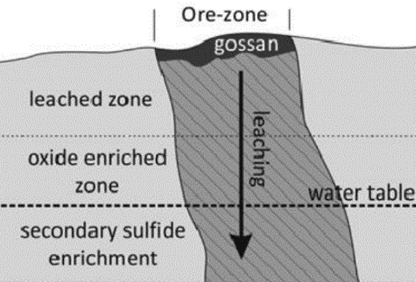
Figure 1 : Schematic cross-section of a classic gossan. (Harris et al., 2015)
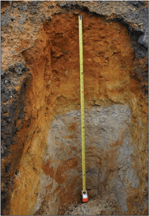
Figure 2 : Classical vertical profile of a gossan. Axel Heiberg Island, Nunavut. (Williamson et al., 2011)
Analogs to paleo-hydrothermal systems on Mars
The exact processes that led to the formation of gossans on Earth and paleo hydrothermal systems on Mars are poorly known. Paleo hydrothermal systems on Mars are important as they are one of the key places to look for signs of life.
These systems contain jarosite, a mineral that is one of the key astrobiological parameters that can be studied to understand the past aqueous environment and habitability of Mars. The potassium content of jarosite can be used to determine when water was present at the sample location, by a 40Ar/39Ar dating [2,3], and it can preserve organic compounds such as the amino acid glycine [4].
In humid climates, jarosite decomposes to produce ferric oxyhydroxides, a rust-like compound. Therefore, jarosite can only be studied in places where arid climatic conditions have stopped this degradation process [5].
Jarosite has been identified at several locations on Mars, including Meridiani Planum [6,7], Valles Marineris [8,9] and Gale Crater [10]. Jarosite has also been identified in Canadian Arctic gossans [11], providing an invaluable opportunity to study the formation of paleo hydrothermal systems on Mars and to characterize their potential biosignatures.
Learn more about our study region, the Canadian Arctic, and its gossans...
References
Canadian Space Agency (2017) Canadian Space Exploration - Science and Space Health priorities for Next Decade and Beyond, online (accessed 10-07-2019), Canadian Space Exploration: Science and Space Health Priorities 2017 report.
Kula and Baldwin (2011) Jarosite, argon diffusion, and dating aqueous mineralization on earth and Mars, Earth and Planetary Science Letters, 310(3–4), 314–318.
Martin et al. (2017) A two‐step K‐Ar experiment on Mars: Dating the diagenetic formation of jarosite from Amazonian groundwaters, Journal of Geophysical Research: Planets, 122(12), 2803-2818.
Kotler et al. (2008) Glycine Identification in Natural Jarosites Using Laser Desorption Fourier Transform Mass Spectrometry: Implications for the Search for Life on Mars, Astrobiology, 8(2), 253-266.
Madden et al. (2004) Jarosite as an indicator of water-limited chemical weathering on Mars, Nature, 431(7010), 821-823.
Christensen et al. (2004) Mineralogy at Meridiani Planum from the Mini-TES Experiment on the Opportunity Rover, Science, 306(5702), 1733-1739.
Klingelhöfer et al. (2004) Jarosite and Hematite at Meridiani Planum from Opportunity's Mössbauer Spectrometer, Science, 306(5702), 1740-1745.
Viviano et al. (2013) Implications for early hydrothermal environments on Mars through the spectral evidence for carbonation and chloritization reactions in the Nili Fossae region, Journal of Geophysical Research Planets, 118(9), 1858-1872.
Cull et al. (2014) A new type of jarosite deposit on Mars: Evidence for past glaciation in Valles Marineris?, Geology, 42(11), 959-962.
Rampe et al. (2017) Mineralogy of an ancient lacustrine mudstone succession from the Murray formation, Gale crater, Mars, Earth and Planetary Science Letters, 471, 172-185.
Percival and Williamson (2016) Mineralogy and spectral signature of reactive gossans, Victoria Island, NT, Canada, Applied Clay Science, 119, 431–440.